With rainfall totals in the double digits NASA estimated more than 20 inches (508 millimeters) rivers were rapidly rising, causing serious flooding.
But what's causing this historic flooding in areas that rarely receive such significant rainfall days? An "inland sheared tropical depression" is how the National Oceanic and Atmospheric Administration's National Weather Service (NWS) described the heavy rain event on Friday morning (Aug.
"Like a tropical depression, the low had a warm core, and the counterclockwise flow of air around the storm brought huge amounts of tropical moisture from the near-record-warm waters of the Gulf of Mexico and northwest Atlantic northwards over land," meteorologists Jeff Masters and Bob Henson wrote on their blog, Weather Underground.
A combination of tropical moisture and low pressure fueled the immense rainfall in Louisiana and southwest Mississippi, the meteorologists said.
While, historically, such rain events are incredibly rare, this is at least the eighth 500-year rainfall event in America since just last May, Holthaus said.
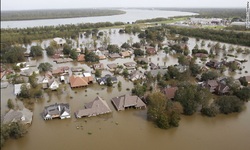
With rainfall totals in the double digits NASA's Global Precipitation Measurement mission estimated more than 20 inches (508 millimeters) of rainfall in large areas of southeastern Louisiana and southern Mississippi rivers were rapidly rising, causing serious flooding.
At least six rivers in Louisiana have hit record levels since the rainfall event began on Friday, reported the Weather Channel.
The amount of rain Louisiana has received in just one night is more than Turlock has received in two years. This is highly dangerous and is leaving many residents homeless and fearful for what will happen next.
http://www.livescience.com/55786-science-of-historic-louisiana-flooding.html
But what's causing this historic flooding in areas that rarely receive such significant rainfall days? An "inland sheared tropical depression" is how the National Oceanic and Atmospheric Administration's National Weather Service (NWS) described the heavy rain event on Friday morning (Aug.
"Like a tropical depression, the low had a warm core, and the counterclockwise flow of air around the storm brought huge amounts of tropical moisture from the near-record-warm waters of the Gulf of Mexico and northwest Atlantic northwards over land," meteorologists Jeff Masters and Bob Henson wrote on their blog, Weather Underground.
A combination of tropical moisture and low pressure fueled the immense rainfall in Louisiana and southwest Mississippi, the meteorologists said.
While, historically, such rain events are incredibly rare, this is at least the eighth 500-year rainfall event in America since just last May, Holthaus said.
With rainfall totals in the double digits NASA's Global Precipitation Measurement mission estimated more than 20 inches (508 millimeters) of rainfall in large areas of southeastern Louisiana and southern Mississippi rivers were rapidly rising, causing serious flooding.
At least six rivers in Louisiana have hit record levels since the rainfall event began on Friday, reported the Weather Channel.
The amount of rain Louisiana has received in just one night is more than Turlock has received in two years. This is highly dangerous and is leaving many residents homeless and fearful for what will happen next.
http://www.livescience.com/55786-science-of-historic-louisiana-flooding.html
